
Business Details
25 Years
experience
Your Trusted Partner for Land Surveying Solutions in Geraldton
Established in 2001, Quantum Surveys has been delivering industry-leading land surveying and spatial science services across regional Western Australia. Our expertise spans commercial and residential developments, construction, engineering, and mining projects, supported by a commitment to leveraging cutting-edge technology and a team of highly skilled professionals. We prioritise quality assurance through compliance with ISO 45001:2018 (Occupational Health and Safety) and ISO 9001:2015 (Quality Management) standards, ensuring safety, precision, and client satisfaction.Our vision focuses on excellence, continuous employee development, and supporting local communities and businesses. With advanced tools like Trimble GPS and AutoCAD software, we provide accurate, efficient solutions tailored to client needs, from boundary re-establishment to complex mine site surveys. Our collaborative approach, combined with decades of experience, positions us as a trusted partner for diverse surveying challenges.

Services
General Surveys
Land Development
Construction Surveys
UAV Surveys
Volume Surveys
Mine Site Surveys
Building Setout
Environmental Surveys
Strata Subdivisions
Details
- Year established: 2001
Highlights and features
- We have over 20 years of experience in land and mining surveying across Western Australia.
- Our team utilises Trimble GPS and AutoCAD software for accurate, efficient results.
- We are certified under ISO 45001:2018 and ISO 9001:2015 quality and safety standards.
- Our directors collaborate with specialist planners to ensure compliant land development.
- We prioritise employee training and local community engagement in regional WA.
Associations and certifications
- ISO 45001:2018
- ISO 9001:2015
Services
Land Development Surveys
We specialise in land development surveys for green title, survey-strata, and built-strata subdivisions. Our services include boundary re-establishment, lot design, and compliance with Western Australian Planning Commission requirements. Clients benefit from precise Deposited Plans and expert guidance through approval processes.
Construction Surveys
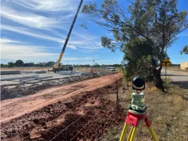
Our construction surveys ensure accurate building placement using computer-generated layouts and boundary re-establishment. We provide setout for foundations, tilt-up panels, and infrastructure, minimising errors and delays. Clients receive detailed survey plans for residential and commercial projects.
UAV Surveys
UAV surveys deliver high-resolution aerial photography, digital terrain models, and contour mapping. This technology enables efficient site analysis for agricultural, mining, and civil projects. Clients gain cost-effective, detailed insights for planning and monitoring.
Mine Site Surveys
We conduct volume surveys, pit wall monitoring, and drill hole mapping for open-cut mines. Our services support resource management, rehabilitation, and compliance. Clients rely on our expertise in tailings dam surveys and aerial targeting for operational efficiency.
Environmental Surveys
Environmental surveys assess mine site rehabilitation, groundwater boreholes, and accident impacts. We provide data for compliance and sustainability reporting. Clients benefit from precise monitoring to meet regulatory standards and ecological goals.
People
Roger Hunt
Director
Roger Hunt is a licensed surveyor with extensive experience in land and engineering surveying. He leads Quantum Surveys' strategic direction and client relations.
Peter Chaplyn
Director
Peter Chaplyn, a certified RPAS controller, oversees UAV operations and technological innovation. He ensures compliance with aviation and surveying standards.
Peter Redway
Director
Peter Redway manages operational excellence and quality assurance. His expertise spans construction and mining surveying projects across regional WA.
Daniel Welsh
Surveyor
Daniel Welsh is a certified RPAS controller specialising in UAV data collection and processing for mining and civil projects.
Ryan Trump
Surveyor
Ryan Trump conducts field surveys and data analysis, supporting land development and construction projects with precision and technical skill.
Questions
What areas do Quantum Surveys service?
We operate across regional Western Australia, including the Pilbara, Gingin, and Wiluna regions.
What surveying technologies do you use?
We utilise Trimble GPS, robotic total stations, UAVs, and AutoCAD software for accurate data collection and analysis.
Are you certified under quality standards?
Yes, we comply with ISO 9001:2015 (Quality) and ISO 45001:2018 (Safety) management systems.
Can you assist with land subdivision approvals?
We collaborate with licensed planners to navigate WAPC and local government requirements for subdivisions.
Do you offer UAV/Aerial Survey services?
Yes, our UAV services include aerial photography, contour mapping, and volume calculations for diverse industries.
How do you ensure survey accuracy?
We combine advanced technology, certified professionals, and rigorous quality audits to guarantee precision.
Reviews (1)
Tom Cameron
Dec 13, 2021
Report
Great quality and great advice. Tell these guys what your project is and they will tailor the best surveying solution for you.