
Business Details
Professional Surveying Services in Ilfracombe
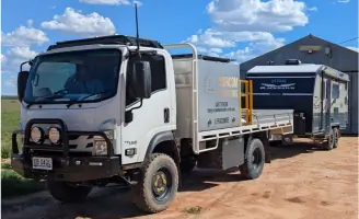
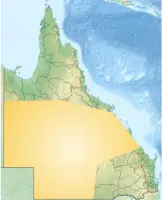
Morcom Surveyors have been delivering professional surveying solutions across Queensland for over 25 years. As registered cadastral and consulting surveyors, we specialise in boundary identification, land subdivision, engineering surveys, and construction set-out services. Our team operates across Central West and Central Queensland, covering RAPAD Council areas and extending to SW QLD and Rockhampton regions. We utilise advanced robotic total stations, GNSS equipment, and UAV drone technology to ensure precision in cadastral, engineering, and GIS mapping projects. Our mobile survey facility enables efficient execution of remote and large-scale jobs, supported by satellite communication for safety and real-time data management.With expertise in mining lease surveys, underground service location, and machine guidance systems, we provide defensible, legislation-compliant survey outcomes. Our approach combines technical excellence with practical field support, maintaining strict adherence to industry standards. We prioritise client education about survey requirements for property transactions and development projects. Our equipment hire services support sub-50mm accuracy requirements for infrastructure and environmental mapping. As a growing team of qualified professionals, we remain committed to advancing surveying practices through technology and field innovation.
Services
Cadastral Surveys
Engineering Surveys
UAV Mapping
Boundary Identification
Land Subdivision
Construction Setout
Underground Locating
GIS Services
Equipment Hire
Mining Lease Surveys
Highlights and features
- We have over 25 years of Queensland surveying experience
- Our team includes registered cadastral and consulting surveyors
- We operate a fully equipped mobile survey facility
- We utilise advanced GNSS and UAV drone technology
- Our equipment hire supports sub-50mm accuracy requirements
Associations and certifications
- Registered Surveyor (Cadastral and Consulting Endorsement)
Services
Cadastral Surveys
We conduct precise cadastral surveys for property boundaries, subdivisions, and amalgamations. Our services ensure legal compliance for land transactions and development projects. Utilising registered surveyors and advanced GNSS technology, we deliver defensible boundary determinations across Queensland's diverse terrain.
Engineering Surveys
Our engineering surveys support infrastructure projects with accurate set-out for roads, buildings, and utilities. We provide control networks and UAV mapping for construction monitoring. Specialised services include solar farm control surveys and machine guidance systems for precision earthworks.
UAV Mapping
We employ drone technology for aerial mapping, volume calculations, and detailed topographic surveys. Our UAV services capture high-resolution imagery for GIS integration and project documentation. This technology enables efficient data collection in remote or complex terrain.
Equipment Hire
We offer GPS base/rover kits and standalone units for sub-50mm accuracy requirements. Our hire equipment supports rural road construction, dam projects, and GIS mapping. Clients receive technical support for machine guidance systems and field data collection.
Underground Locating
Our team locates and maps underground utilities including communications, electricity, and sewer infrastructure. We use advanced detection equipment for asset management and safety compliance. This service supports pre-construction planning and maintenance operations across Queensland.
People
Tony Morcom
Registered Surveyor
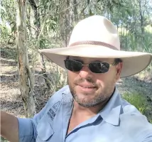
With over 25 years' experience, Tony Morcom leads our cadastral and consulting survey services. As a registered surveyor with Queensland's RICS equivalent, he specialises in boundary determination and land development projects. Tony manages our mobile survey facility operations and technical equipment integration.
Questions
What areas do Morcom Surveyors service?
We operate across Central West and Central Queensland, covering RAPAD Council regions, Rockhampton areas, and extending to SW QLD including Quilpie and Bulloo Shires.
What survey equipment do you hire?
We hire GPS base/rover kits for sub-50mm accuracy, standalone units for remote projects, and machine guidance systems for construction equipment.
Are your surveyors qualified?
Yes, our team includes registered cadastral and consulting surveyors with Queensland's professional accreditation, maintaining 25+ years of combined industry experience.
Do you handle remote location surveys?
Our mobile survey facility with satellite communication enables operations in remote Queensland locations, supporting extended fieldwork with on-site office capabilities.
What construction survey services do you offer?
We provide road and building set-out, solar farm control surveys, and UAV mapping for construction monitoring using robotic total stations and GNSS equipment.
How do you ensure survey accuracy?
We use calibrated robotic total stations, GNSS systems, and UAV technology with smart data management to maintain sub-50mm accuracy standards across all projects.