Business Details
Trusted Surveying Services in Byron Bay
Established over three decades ago, Byron Bay Surveying has grown to become a leading surveying firm in the Northern Rivers region of New South Wales. Our team combines extensive industry experience with cutting-edge technology to deliver precise and reliable surveying solutions for residential, commercial, and government projects. With offices in Byron Bay and Alstonville, we service developments across the north coast and provide expert advice for international ventures. Our services span property surveys, construction setout, land development, and infrastructure monitoring, underpinned by a commitment to safety, precision, and client-focused communication.We prioritise transparency and thoroughness, ensuring clients receive actionable data to inform critical decisions. Our teams dedication to continuous professional development guarantees alignment with industry advancements, while our local roots drive a commitment to enhancing the Byron Bay community through quality service.
Services
Property Surveys
Construction Surveys
Land Development
Aerial Surveys
Infrastructure Surveys
Topographical Surveys
Level Certification
Monitoring Services
Measured Building Surveys
Highlights and features
- We have over 30 years of experience in land surveying across NSW and Queensland.
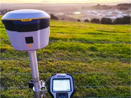
- Our team uses advanced 3D technology and laser scanning for accurate data collection.
- We provide tailored solutions for complex projects, from small residential builds to major infrastructure.
- Our local knowledge ensures deep understanding of regional planning and development challenges.
- We prioritise health and safety, minimising risks for clients, staff, and the public.
Services
Property Surveys
We conduct boundary marking, title definition, and detail surveys to clarify property lines and legal descriptions. Our precise measurements ensure compliance with NSW regulations and support informed property transactions or developments. Clients receive comprehensive reports to resolve disputes or plan construction projects confidently.
Construction Surveys
From small residential builds to high-rise structures, we provide accurate setout for foundations, utilities, and infrastructure. Our team uses laser scanning and GPS technology to align projects with design specifications, ensuring structural integrity and reducing costly errors during construction phases.
Aerial Surveys
Our drone-based aerial surveys capture high-resolution topographical data for large-scale projects. This technology enables efficient mapping of challenging terrain, flood-affected areas, or infrastructure corridors, delivering 3D models that inform planning and design decisions with minimal site disruption.
Land Development
We facilitate strata and community title subdivisions, including body corporate establishment. Our surveys define lot boundaries, easements, and common property, ensuring compliance with local council requirements and streamlining approval processes for residential or commercial developments.
Infrastructure Surveys
We map underground utilities, pipelines, and sewer systems using non-invasive techniques. These surveys identify service locations to prevent damage during excavation and support maintenance planning, enhancing safety and reducing project delays for municipal or industrial clients.
People
Bill Nagel
Director
With over three decades of surveying experience, Bill leads Byron Bay Surveyings technical operations. His expertise in land development and infrastructure projects ensures clients receive strategic, data-driven solutions tailored to complex regulatory and environmental challenges.
Lucas Flumm
Surveyor
Lucas specialises in construction setout and aerial mapping, leveraging advanced drone technology to deliver precise geospatial data. His focus on innovation and client collaboration supports efficient project outcomes for residential and commercial developments.
Questions
What surveying services do you offer?
We provide property surveys, construction setout, land development, aerial mapping, infrastructure monitoring, and topographical surveys for residential, commercial, and government clients.
Do you work outside the Northern Rivers region?
While based in Byron Bay, we are licensed to operate statewide in NSW and Queensland and offer expert advice for projects nationwide.
How do you ensure accuracy in your surveys?
We use advanced 3D technology, laser scanning, and drone mapping to guarantee precision and reliability in all our surveying projects.
Can you assist with urgent surveying needs?
Contact us directly to discuss time-sensitive projects—we prioritise clear communication and timely delivery of actionable data.
What safety measures do you follow?
We adhere to strict health and safety protocols to protect our team, clients, and the public during all surveying operations.
Reviews (2)
Mal Riddle
Oct 13, 2019
Report
Bill was on time and reasonably priced to survey our house for our new granny flat. Highly recommend his services.
Andrea M.
Jun 02, 2019
Report
Bill at Byron Bay Surveying was fantastic to deal with. Ive never needed a surveyor before and found he was happy to come out to provide a quote within the week when other businesses had a four week wait! He easily answered any questions I had (I wanted a boundary line on my property checked for a new fence), and he kept me informed of the process all the way through. Pricing was competitive and the work was done quickly. Highly recommended!